Rideau Canal
The Rideau Canal is a 202-kilometre historic waterway connecting Ottawa on the Ottawa River to Kingston on Lake Ontario. Constructed between 1826 and 1832 as a strategic military supply route following the War of 1812, it is the oldest continuously operated canal system in North America. Today, managed by Parks Canada as a National Historic Site and designated a UNESCO World Heritage Site in 2007, the canal is a premier recreational destination for boating, paddling, and, in winter, the world's largest skating rink. It remains a celebrated symbol of 19th-century engineering and a vital part of Canadian heritage tourism.
Historical Context and Construction
The Rideau Canal's origins are rooted in the geopolitical tensions following the War of 1812. British military planners, fearing a potential American invasion via the St. Lawrence River that would cut off the vital supply line between Montreal and the Kingston naval base, sought an alternative inland route. Initial surveys for a canal were conducted by Lieutenant Joshua Jebb in 1816 and civilian surveyor Samuel Clowes between 1823 and 1824. The project gained crucial support from the Duke of Wellington, who advocated for its construction as part of Canada's defence system in a memorandum dated March 1, 1819. In 1826, Lieutenant-Colonel John By of the Royal Engineers was appointed superintending engineer to oversee the monumental task. By adopted an innovative slackwater design, using dams to flood rapids and create a navigable channel, which proved more efficient than digging lengthy bypass canals.
Construction relied on a workforce of thousands, primarily Irish, Scottish, and French-Canadian labourers, along with Algonquin workers, with private contractors like John Redpath, Thomas McKay, Robert Drummond, Thomas Phillips, and Andrew White managing specific sections. The project faced immense challenges, including difficult terrain and widespread disease. An estimated one thousand workers died during construction, mostly from malaria and other illnesses, with a smaller number from accidents such as the seven accidental deaths recorded in 1827. The canal was officially opened for navigation in the spring of 1832, with the first full steamboat transit made by Robert Drummond's steamboat Rideau from Kingston to Bytown (now Ottawa) between May 22 and May 29, 1832, carrying Colonel By and his family. The final cost was £822,804, a significant overrun that led to Colonel By being recalled to London without official recognition for his achievement.
Engineering and Waterway Features
The Rideau Canal is a masterpiece of early 19th-century engineering, integrating natural rivers and lakes with man-made channels. The route incorporates sections of the Rideau and Cataraqui rivers and traverses numerous lakes, including Lower, Upper and Big Rideau lakes, as well as Newboro, Opinicon, Sand, Whitefish, and Cranberry Lakes. Only about 19 kilometres of the 202-kilometre route is entirely artificial. This is accomplished through a series of 45 locks grouped at 23 lockstations along the main route, plus two additional locks on the Tay Canal branch to Perth. The locks are primarily hand-operated, preserving the historic character of the canal, and the lock gates have a lifespan of approximately 12 to 15 years.
The canal's defining slackwater technology involved building dams to raise water levels, submerging rapids and creating calm, navigable pools. One of the most impressive structures is the Jones Falls Dam, which is 110 metres long and 18.3 metres high. The lock gates, originally built on-site by carpenters and blacksmiths, are now constructed from Douglas Fir in Smiths Falls and are designed with a mitre shape to form a watertight seal. It can take up to two months to build a single set of gates. Each lock cycle uses approximately 1.3 million litres of water. For navigation, the canal typically accommodates pleasure boats up to 27.4 metres in length, 7.9 metres in width, and with a draft of up to 1.5 metres, though in special circumstances it can handle vessels up to 33.5 metres long and 9.1 metres wide.
Commercial Era and Transition to Recreation
Following its completion, the Rideau Canal quickly became a major commercial artery, providing a safer and easier route for shipping between Montreal and the Great Lakes than the treacherous rapids of the upper St. Lawrence River. It facilitated the movement of tens of thousands of immigrants from the British Isles westward and was vital for transporting timber, grain, and minerals from Canada's hinterland. At its peak in 1841, the canal saw heavy traffic, with some 19 steamboats, 3 self-propelled barges, and 157 unpowered or tow barges recorded using the waterway. However, the canal faced competition from the Erie Canal in New York State, and some shipments were diverted to Oswego, New York, to reach New York City markets via the Hudson River.
Its commercial dominance was short-lived. The opening of the Prescott and Bytown Railway in December 1854 offered faster freight service, and the subsequent improvement of the St. Lawrence River route, with rapids made navigable by a series of locks by 1849 and culminating in the modern Saint Lawrence Seaway in the 1950s, rendered the canal obsolete for large-scale commerce. This shift marked the beginning of the canal's modern identity as a recreational waterway. The decline of freight traffic coincided with the rise of pleasure boating, particularly after the introduction of the outboard motor and the increasing use of inland waterways following World War I. Today, the Rideau Canal is a central component of the Great Loop, a popular boating circuit connecting waterways in eastern North America. The navigation season is officially managed by Parks Canada from mid-May to mid-October, during which thousands of boaters and paddlers traverse its length. The journey from Ottawa to Kingston typically takes three to five days by motorboat, with opportunities for overnight mooring at lockstations and visits to waterfront communities.
Heritage Structures and Museums
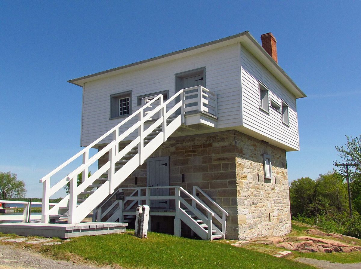
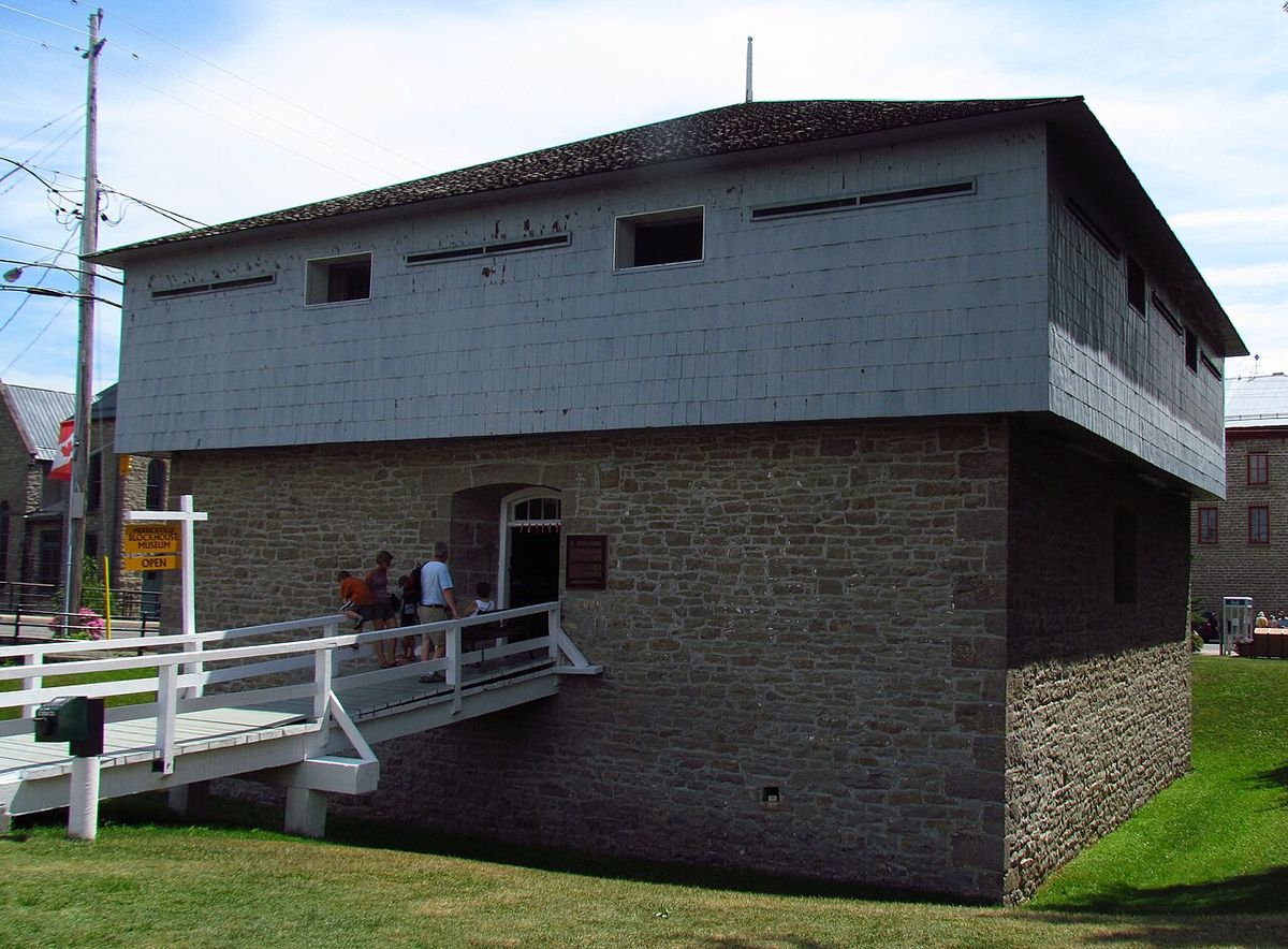
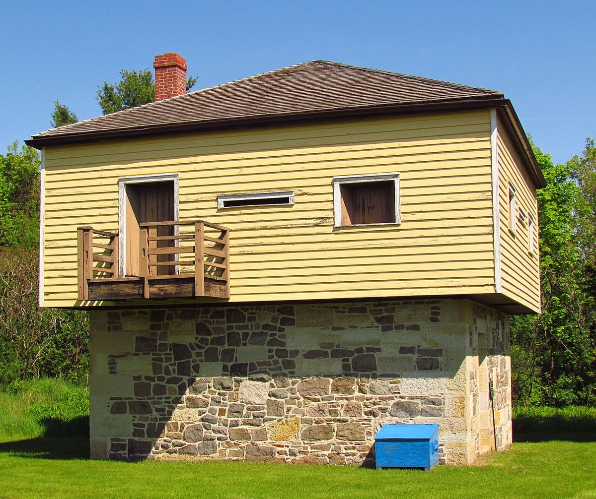
Scattered along the canal are numerous well-preserved structures that testify to its original military and operational purposes. Four defensible stone blockhouses were constructed between 1826 and 1832 at Merrickville, Kingston Mills, Newboro, and Rideau Narrows. The Merrickville Blockhouse was used briefly during the 1837 Rebellion before becoming a lockmaster's residence, with its upper floor removed in 1909 and restored in 1960 as a museum. The Kingston Mills Blockhouse was also used in 1837 to 1838, then enlarged as a residence before being restored to its 1830s layout in the 1960s. The Newboro Blockhouse, built by the British Ordnance Department, and the Rideau Narrows Blockhouse, built by William H. Tett, followed similar paths of conversion and restoration. All four are accessible to the public. The Commissariat Building in Ottawa, built in 1827, is the oldest surviving stone building in the city. It served as a storehouse and office for the British military, featuring three floors, a secure vault, and a block and tackle on the front for hauling goods, and now houses the Bytown Museum.
Several historic cemeteries along the route serve as solemn reminders of the canal's construction era. Three are open to visitors: Chaffey's Cemetery and Memory Wall at Chaffey's Lock, used from 1825 to the late 19th century. The Royal Sappers and Miners Cemetery near Newboro, used from 1828 to the 1940s. Memorials, including Celtic Crosses in Ottawa, Kingston, and Chaffeys Lock, honour the workers who died during construction. The canal's historical significance has been formally recognized through multiple designations and plaques.
- Designated a Canadian Heritage River in 2000.
- Inscribed as a UNESCO World Heritage Site in 2007, recognized as the best preserved slackwater canal in North America.
- Featured on multiple Canada Post stamps, including 45-cent stamps in 1998 and a $2.50 international rate stamp in 2014.
- Twinned with the Caledonian Canal in Scotland in 1993.
The Ontario Heritage Trust has erected plaques at Kingston Mills, Smiths Falls, and Rideau Lakes. An additional plaque was placed by the Ontario Archaeological and Historic Sites Board at Jones Falls Lockstation. This plaque commemorates Lieutenant Colonel John By, the superintending engineer in charge of the canal's construction. It notes the Rideau Canal is 123 miles long and incorporates 47 locks, 16 lakes, two rivers, and a major dam at Jones Falls.
The Rideau Canal Skateway and Winter Use
Each winter, a 7.8-kilometre section of the canal through downtown Ottawa is transformed into the Rideau Canal Skateway, officially recognized as the world's largest skating rink. The tradition began in the winter of 1970-71 and has become a defining Canadian winter experience. The Skateway's surface area is equivalent to 90 Olympic-sized hockey rinks, running from the Hartwells Lockstation at Carleton University to the locks between the Parliament Buildings and the Château Laurier, including Dow's Lake. It is a central feature of Ottawa's Winterlude festival and was cited by CNN Travel as a key reason for visiting the city in 2023. The ice must reach a thickness of 30 centimetres to open, which typically requires 10 to 14 consecutive days of temperatures between -10 and -20 degrees Celsius.
The Skateway is free to access and features universally accessible ramps, heated change facilities, and rental services for skates and sleighs. Beavertail stands offer classic Canadian pastries and hot chocolate, and local businesses like Dunrobin Distilleries provide beverages for those 19 years of age and older. Non-skaters are welcome to walk on the pathways alongside the ice. The skating season usually runs from early January to late February or March, depending on weather conditions. For the 2026 season, a 3.4-kilometre section from the Somerset West access point to the Bank Street Bridge was scheduled to open on December 31 at 8 a.m. The National Capital Commission provides official updates on openings and conditions for skaters, and general inquiries can be directed to Ottawa Tourism.
Recreation and Tourism Along the Waterway
The Rideau Canal offers a wide array of recreational activities that draw visitors year-round. During the navigation season, boating is the primary attraction, with options ranging from private cabin cruisers and rented houseboats to guided sightseeing tours offered in Ottawa, Kingston, Merrickville, and Chaffeys Lock. A cruise line operates the ship Kawartha Voyageur on the canal. Paddling by canoe or kayak is also popular, with rentals available at locations like the Dows Lake Pavilion in Ottawa and in Kemptville. For those exploring by land, a network of cycling and walking trails, including the Rideau Canal Promenade with its seven informative plaques, runs alongside much of the waterway. Communities along the canal, from Manotick and Kars to Burritts Rapids, Rideau Ferry, Portland, Westport, Seeleys Bay, and Perth, host festivals, farmers' markets, and cultural events that celebrate the region's heritage.
Parks Canada facilitates visits by providing services such as overnight mooring, camping at lockstations, and unique accommodations like oTENTik tents. The agency also offers a central online resource for 2026 providing real-time updates on lock, bridge, and service status to help travellers plan their journeys. Key events that leverage the canal's setting include Winterlude in Ottawa, the Lock & Paddle event, and the Taste of Manotick festival. The canal's status as a UNESCO World Heritage Site and its proximity to other national historic sites like the Trent-Severn Waterway, Fort George, and Thousand Islands National Park make it a central part of cultural tourism in Eastern Ontario.
Visiting the Canal: Practical Information
Planning a visit to the Rideau Canal requires consideration of season and mode of travel. The official navigation season for boating runs from mid-May (Victoria Day) to mid-October (Thanksgiving), after which the waterway is closed and not maintained by Parks Canada. During this off-season, aids to navigation may be missing and unmarked hazards may exist. Boaters must consult Notices to Mariners and official Government of Canada Nautical Charts before departure and should be aware that weather on the canal can change very quickly. The canal is accessible by car via roads like Ontario Highway 15, which parallels much of the route between Kingston and Smiths Falls. In Ottawa, paid parking is available along the canal. For the Skateway, skaters should monitor the National Capital Commission's official website for opening status and conditions, and can contact Ottawa Tourism at 1-833-864-7839 for general inquiries.
| Activity | Season | Key Locations |
|---|---|---|
| Boating & Cruises | Mid-May to October | Ottawa, Kingston, Merrickville, Chaffeys Lock |
| Canal Skateway | January to early March | Downtown Ottawa to Dow's Lake |
| Paddling (Canoe/Kayak) | May to October | Dows Lake Pavilion, Kemptville |
| Cycling & Walking | Year-round | Rideau Canal Promenade, waterfront trails |
| Festivals & Events | Various | Ottawa (Winterlude), Manotick, Perth, Smiths Falls, Westport |
| Houseboat Rental | Navigation Season | Various operators along the canal |
Visitors to the Rideau Canal can contact the Rideau Canal National Historic Site for information. Weather conditions on the waterway can change very quickly. Visitors should prepare with appropriate safety gear for their activities. It is also important to check for official updates from Parks Canada and the National Capital Commission.
Ecological and Geographical Setting
The Rideau Canal winds through four distinct natural landscapes along its 202-kilometre route from Ottawa to Kingston, as identified by Parks Canada. The waterway is home to many species of birds, reptiles, amphibians, mammals and fish, creating a rich ecological corridor. The route begins in the urban setting of Ottawa, transitioning into the agricultural lands of the Rideau River floodplain, before entering the rocky, forested terrain of the Canadian Shield in the Rideau Lakes region, and finally descending through the limestone plains to Kingston on Lake Ontario. This varied geography contributes to the scenic beauty that defines the canal experience for boaters, cyclists, and hikers. The canal's construction permanently altered some of these landscapes through the creation of dams and flooded areas, such as the Cranberry floodplain, which was rendered navigable by mill dams even before the canal was built.
The watershed divide, where water flows north to the Ottawa River or south to Lake Ontario, is located at Newboro. The summit of the canal is the body of water known as Upper Rideau Lake. The original surveyors, including Samuel Clowes in 1823-24, favoured the longer route via the Rideau Lakes precisely because this summit was a large, stable lake. The canal incorporates 16 lakes and two rivers along its length. Water management on the canal is a continuous responsibility for Parks Canada, involving careful control of water levels and drawdowns in coordination with local conservation authorities to balance navigation, ecological health, and shoreline property interests. The canal passes through a transition zone between the Canadian Shield and the Adirondack Mountains, with the Thousand Islands region located nearby.
Questions about Rideau Canal
How long does it take to boat the entire Rideau Canal?
A one-way transit of the entire 202-kilometre Rideau Canal typically takes between three to five days by motorboat, depending on weather, lock transit times, and stops. The canal is navigable during the official Parks Canada season from mid-May to mid-October. Many boaters choose to make it a leisurely trip, stopping overnight at lockstations or in the numerous communities along the route. Rented houseboats are a popular way to experience the full journey, and it takes approximately five days to travel the entire length by houseboat.
When is the Rideau Canal Skateway open?
The Rideau Canal Skateway in Ottawa is typically open from early January to late February or early March, but the season is entirely dependent on weather. The ice must be at least 30 centimetres thick to open, requiring a sustained period of cold temperatures between -10 and -20 degrees Celsius for 10 to 14 days. The National Capital Commission provides official updates on openings and conditions. For the 2026 season, a 3.4-kilometre section from the Somerset West access point to the Bank Street Bridge was scheduled to open on December 31 at 8 a.m.
Why is the Rideau Canal a UNESCO World Heritage Site?
The Rideau Canal was inscribed as a UNESCO World Heritage Site in 2007. UNESCO recognized it as the best preserved example of a slackwater canal in North America. It is the only canal from the great North American canal-building era of the early 19th century that remains operational along its original line with most of its original structures intact. The site was recognized as a work of human creative genius, demonstrating the use of European slackwater technology in North America on a large scale. It was also recognized as an extensive, well preserved and significant example of a canal used for military purposes linked to a significant stage in human history, specifically the fight to control the north of the American continent.
Who built the Rideau Canal and why?
The Rideau Canal was built by the British government following the War of 1812. The primary purpose was military, to provide a secure supply route between Montreal and the Kingston naval base, safe from potential American attack along the St. Lawrence River. Construction was supervised by Lieutenant-Colonel John By of the Royal Engineers from 1826 to 1832. The labour force consisted of thousands of Irish, Scottish, French-Canadian, and Algonquin workers, with private contractors like John Redpath and Thomas McKay managing various sections. The canal was intended as part of a wider defence system that included Citadel Hill in Halifax and Fort Henry in Kingston.
Can you drive along the Rideau Canal?
Yes, you can drive to and alongside many sections of the Rideau Canal. Ontario Highway 15 runs parallel to a significant portion of the waterway between Kingston and Smiths Falls. In Ottawa, roads and parkways follow the canal through the city. Driving provides access to lockstations, museums like the Bytown Museum, parks, and the communities along the route. However, the canal itself is strictly a waterway and skating rink, not a drivable road, and visitors are encouraged to explore on foot, by bike, or by boat for the full experience.
What are the main towns to visit along the Rideau Canal?
The Rideau Canal passes through or near numerous charming communities. Key towns include Ottawa, the national capital at the northern terminus, and Kingston, the historic limestone city at the southern end on Lake Ontario. Other notable stops include Manotick, known for its historic mill and the Taste of Manotick festival. Merrickville, celebrated for its boutiques and preserved blockhouse. Smiths Falls, a central hub where lock gates are now built. And the picturesque villages of Westport, Portland, Newboro, and Seeleys Bay. Communities connected by navigable waterways include Kemptville and Perth, each offering unique shops, dining, and local heritage attractions.
Sources and further reading
- Rideau Canal (Wikipedia)
- Rideau Canal National Historic Site, Parks Canada (parks.canada.ca)
- Rideau Canal (visitrideaucanal.com)
- Rideau Canal Skateway (ottawatourism.ca)
- Rideau Canal (destinationontario.com)
Checked by the Novello Desserts desk. Last updated 2026-10-24.