Frank Slide
The Frank Slide is the site of Canada's deadliest rockslide, a catastrophic geological event that occurred in the early morning of April 29, 1903. Approximately 110 million tonnes of limestone broke from Turtle Mountain and buried part of the mining town of Frank in what is now Alberta, killing between 70 and 90 people. The immense debris field, which remains largely untouched, is a designated Provincial Historic Site and a major tourist destination in the Crowsnest Pass. The Frank Slide Interpretive Centre, overlooking the site, provides detailed exhibits on the disaster and the region's coal mining history, attracting over 100,000 visitors annually.
The Town of Frank and Turtle Mountain
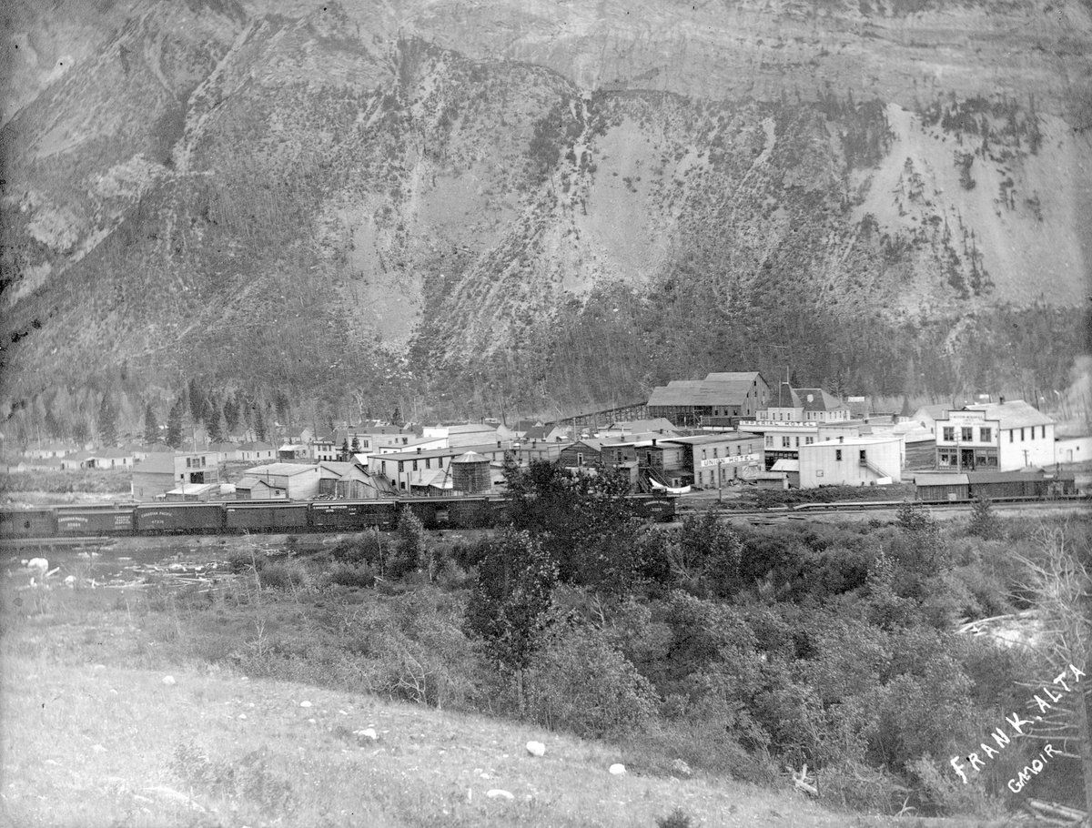
The town of Frank was founded in 1901 in the southwestern corner of the District of Alberta, a region rich in coal deposits discovered the previous year. Named after Henry Frank, a co-owner of the Canadian-American Coal and Coke Company, the town was established to service the local mine. A gala opening on September 10, 1901, drew over 1,400 people from neighbouring communities via special Canadian Pacific Railway trains. By April 1903, the permanent population had reached 600, and the town featured a two-storey school and four hotels. The community was built at the base of Turtle Mountain, a formation with an unstable geological structure. The mountain consisted of an older limestone layer folded over softer materials like shale and sandstone, with erosion creating a steep overhang. Indigenous peoples, including the Blackfoot and Ktunaxa, had long recognized its instability, referring to it as "the mountain that moves" and avoiding camping nearby. In the weeks before the slide, miners working inside Turtle Mountain reported feeling rumblings and noted that supporting timbers in the shafts were cracking under pressure. The mine superintendent reported a "general squeeze" in the mountain at depths between 1,100 and 1,500 metres, where coal was said to have broken from its seam so easily it practically mined itself.
The Catastrophic Slide
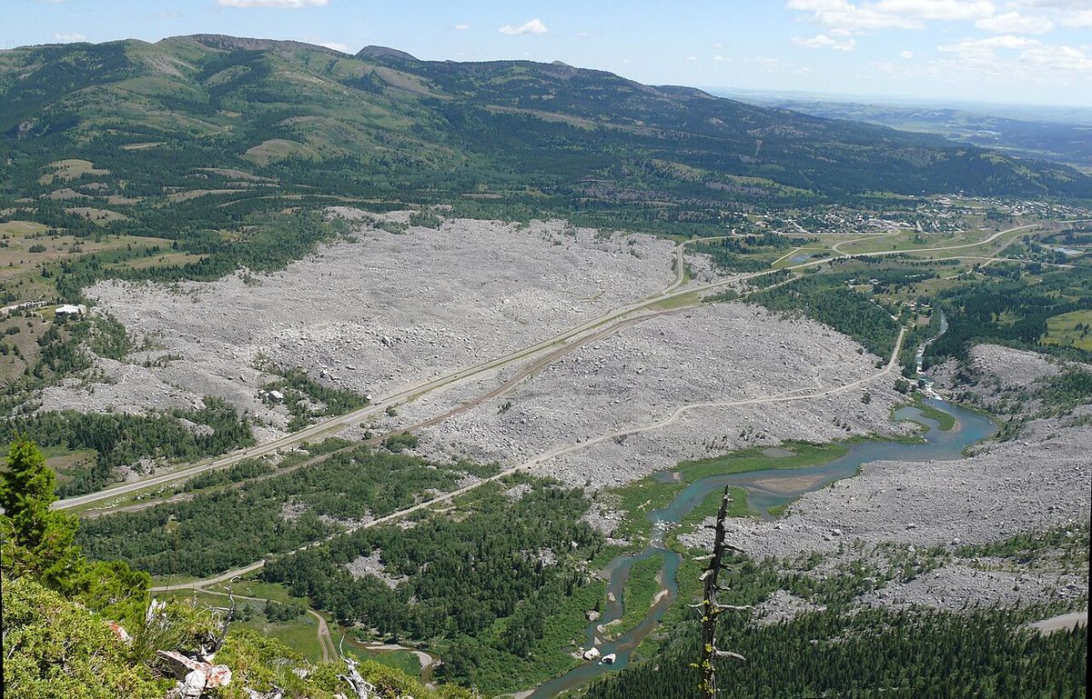
At 4:10 a.m. on April 29, 1903, a section of Turtle Mountain measuring 1,000 metres wide, 425 metres high, and 150 metres deep broke away. The mass of rock, estimated at 110 million tonnes, travelled across the valley at speeds up to 112 kilometres per hour, reaching the opposing hills in about 100 seconds. The sound was heard over 200 kilometres away in Cochrane. The slide buried the eastern outskirts of Frank, destroying seven cottages, several businesses, the cemetery, a two-kilometre stretch of the Canadian Pacific Railway line, and the mine's surface buildings. A freight train crew heard the rumble and sped to safety across the Crowsnest River bridge just seconds before it was destroyed. Initial reports exaggerated the destruction, claiming the entire town was wiped out, though the majority of Frank survived. The death toll remains uncertain, with estimates ranging from 70 to 90 victims. Many bodies were never recovered, with only twelve found initially. The slide is considered the deadliest landslide in Canadian history and was the largest until the Hope Slide in 1965. It is also ranked among the top twenty deadliest rockslides in the world. The slide dammed the Crowsnest River, creating a small lake, and covered approximately three square kilometres of the valley floor with rubble.
Rescue and Survival Stories
Remarkable stories of survival emerged from the disaster. Seventeen miners were working the night shift inside Turtle Mountain when the entrance was sealed. Trapped with rising water, they spent 13 hours digging a narrow escape tunnel through a coal seam to the surface. All seventeen emerged alive late in the afternoon. They had to dig through six metres of coal and 2.7 metres of limestone boulders to reach safety. Tragically, some discovered their families had been killed in the slide. Among the residents in the slide's path, 23 people survived. This included three young girls: Marion Leitch, who was thrown from her home into a hay pile. Gladys Ennis, found in mud outside her home. And Fernie Watkins, found unharmed in the debris. Gladys Ennis, who died in 1995 at age 94, was the last known survivor. Another dramatic rescue involved CPR brakeman Sid Choquette, who ran two kilometres across the falling rocks to flag down an oncoming passenger train, the Spokane Flyer, preventing further loss of life. The CPR later commended his heroism with a letter and a $25 cheque, equivalent to about $750 in 2019. It was later revealed that 128 men scheduled to move into a CPR work camp at the base of the mountain the day before the slide were not there because their train from Morrissey, British Columbia, failed to pick them up, sparing their lives.
Immediate Aftermath and Recovery
The day after the slide, police and doctors arrived from Fort Macleod, and North-West Territories Premier Frederick Haultain visited on May 1. Fearing another slide, Haultain initially ordered the town evacuated, but the order was lifted on May 10 after geologists from the Geological Survey of Canada assessed that the immediate danger had passed. The geologists reported the slide had created two new peaks on the mountain and that the north peak overlooking the town was not in imminent danger. The North-West Mounted Police, reinforced by officers from Cranbrook, Fort Macleod and Calgary, maintained order and prevented looting during the evacuation. Clearing the vital CPR line was a priority, and the railway was rebuilt and operational within three weeks. The mine was also quickly reopened, with passageways cleared by May 30. During this work, rescuers discovered a mine horse named Charlie, who had survived for over a month underground by eating bark and drinking seepage, though he died shortly after being overfed oats and brandy by his rescuers. The town's population rebounded and grew, reaching 1,178 by the 1906 census of the Canadian Prairies. However, due to ongoing concerns about mountain stability confirmed by a Dominion government study, the section of town closest to Turtle Mountain was relocated in 1911.
Causes and Ongoing Geological Study
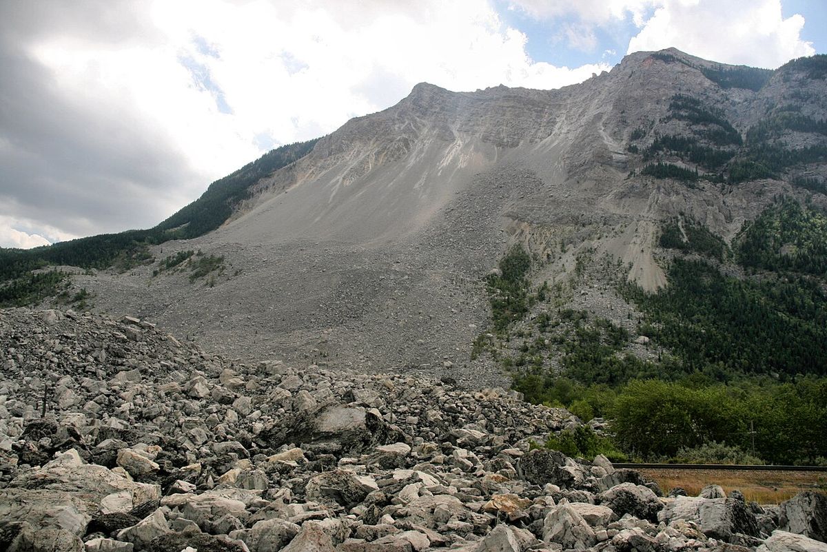
Multiple factors contributed to the Frank Slide. The primary cause was the mountain's inherently unstable anticline structure, where a top-heavy limestone layer overlay weaker shale and sandstone. Cracks and fissures on the eastern face allowed water infiltration. An unusually warm winter with freeze-thaw cycles in early 1903 further weakened the rock. Heavy snowfall in March 1903 was followed by a warm April, causing meltwater to seep into the mountain's core. A sudden cold snap on the night of April 29, with temperatures plunging below -18°C, likely triggered the final collapse by causing rapid expansion within the fissures. The role of coal mining remains debated. While mine owners denied responsibility, later studies suggested mining activity may have disturbed the mountain's delicate equilibrium. The Geological Survey of Canada's initial study concluded mining contributed, while mine engineers argued it did not. The slide created two new peaks on Turtle Mountain, the south peak at 2,200 metres and the north peak at 2,100 metres, and geologists believe another slide from the south peak is inevitable, though not imminent. The site is now one of the most closely monitored slopes in the world. The Alberta Geological Survey operates a network of over 80 monitoring stations on the mountain face to provide early warning. Theories to explain the slide's extensive travel include "air cushion" and "acoustic fluidization," leading geologists to classify it as a "debris avalanche." The mountain continues to be studied as a global case for slope stability research.
The Frank Slide Interpretive Centre and Tourism
The Frank Slide has been a tourist attraction since the day after the disaster. The province built a roadside turnout in 1941 to accommodate visitors, and the site was designated a Provincial Historic Resource in 1977, with a memorial plaque erected in 1978. The area was declared a restricted development zone in 1976, preventing any alteration of the slide debris. The Frank Slide Interpretive Centre opened in 1985 on a bluff overlooking the debris field and underwent a major exhibit upgrade in 2008. The centre features four levels of interactive exhibits and two high-definition documentary shows, including On the Edge of Destruction, detailing the slide's history, causes, and human stories. It also covers broader regional history, including the 1914 Hillcrest Mine Disaster and the community of Crowsnest Pass. An interpretive trail winds through the rubble, offering a stark perspective on the slide's scale. The centre is open year-round, with extended summer hours from mid-May to mid-October, and is closed on Mondays outside the summer season. For the 2026 season, it is scheduled to be open seven days a week from May 15 to October 12, from 10 a.m. to 5 p.m. Admission fees are $18 for adults, $14 for seniors, and reduced rates for youth. The centre serves as a key educational resource, offering field trip programs for various age groups and drawing over 100,000 visitors each year to this significant landmark of Canadian natural and industrial history. Key attractions and related sites in the Crowsnest Pass include the Frank Slide debris field along Highway 3, a two-kilometre stretch where the road is flanked by boulders, and the Frank Slide Interpretive Centre and its interpretive trail starting at the centre. Other important stops are the Leitch Collieries Provincial Historic Site, a free historic stop with the ruins of above-ground processing plants, the Hillcrest Mine Monument and Cemetery commemorating the 1914 disaster that killed 189 men, the Bellevue Underground Mine which offers summer tours of a historic mine shaft, and the demanding hike to the summit of Turtle Mountain for panoramic views of the slide path. The area's tourism integrates the slide with the broader narrative of Alberta's coal mining era, making it a significant heritage corridor. Town boosters had previously sought National Historic Site designation for the slide in 1958, though it was ultimately recognized at the provincial level.
Legends and Cultural Impact
Numerous legends arose in the slide's aftermath, many based on misinformation. A persistent myth claimed the entire town and a bank vault containing $500,000 were buried, though the Union Bank building was untouched until its 1911 demolition. In 1924, a road construction crew worked under police guard due to beliefs they might unearth the fictional buried treasure. Another common tale was of "Frankie Slide," an infant girl falsely presented as the sole survivor. This legend was loosely based on the real survivals of Marion Leitch and Gladys Ennis, but was popularized in a ballad by folk singer Ed McCurdy in the 1950s. The disaster has inspired several other artistic works, becoming a part of Canadian cultural memory. Stompin' Tom Connors later sang "How the Mountain Came Down," and the indie band The Rural Alberta Advantage released "Frank, AB." The event has also been the subject of multiple historical and fictional books, including Frank W. Anderson's Triumph and Tragedy in the Crowsnest Pass, ensuring the story of the slide and the community it affected continues to resonate.
Demographic Changes and Modern Frank
Despite the disaster, Frank's population recovered and grew, nearly doubling to 1,178 by 1906 and reaching a peak of about 1,000 shortly after. Coal production peaked in 1910, but the mine closed permanently in 1917 after becoming unprofitable, leading to a long population decline. The community ceased to be independent in 1979 when it was amalgamated into the Municipality of Crowsnest Pass alongside Blairmore, Coleman, Hillcrest, and Bellevue. Today, Frank is home to approximately 200 residents. The slide area was designated a restricted development zone in 1976, preserving the debris field largely as it was in 1903. This protection, combined with the interpretive centre and its status as a provincial historic site, ensures the Frank Slide remains a powerful and educational destination, commemorating a significant event in Alberta's history. The site continues to be a focus for geological monitoring and public remembrance, connecting visitors to a defining moment in the story of the Canadian Rockies and its industrial past.
Questions about Frank Slide
What caused the Frank Slide?
The slide was caused by a combination of factors. The primary cause was the unstable geological structure of Turtle Mountain, where a heavy limestone layer overlay weaker rock. Contributing factors included water infiltration into fissures, an unusually warm winter with freeze-thaw cycles in early 1903, heavy snowmelt, and a sudden cold snap on the night of the slide. The possible effects of coal mining on the mountain's stability are also debated by geologists.
How many people died in the Frank Slide?
Between 70 and 90 people died in the Frank Slide, making it the deadliest landslide in Canadian history. The exact number is uncertain because an estimated 100 people lived in the slide's direct path and some transient workers may have been camping there. Only twelve bodies were recovered immediately after the disaster, with six more skeletons found during road construction in 1924. The majority of the victims remain permanently buried beneath the 110 million tonnes of limestone rubble.
Can you still see the Frank Slide today?
Yes, the massive debris field from the Frank Slide is still clearly visible and largely unchanged since 1903. The site is a popular tourist destination located along the Crowsnest Highway, where the road cuts through approximately two kilometres of the slide path. The area is protected from alteration as a Provincial Historic Site of Alberta and was designated a restricted development zone in 1976. Piles of limestone boulders remain on both sides of the highway, offering a direct view of the scale of the disaster.
Were there any survivors trapped in the mine?
Yes, seventeen miners survived after being trapped inside the mine when the slide blocked the entrance. They were working the night shift and discovered water entering the tunnels. They dug an escape shaft through a coal seam for approximately thirteen hours, working in pairs as the air grew toxic. All seventeen men emerged alive late in the afternoon on the day of the slide, though some tragically discovered their families had been killed in the devastation above ground.
Is Turtle Mountain still monitored for another slide?
Yes, Turtle Mountain is continuously monitored for stability due to the risk of another rockslide. The Alberta Geological Survey operates a state of the art monitoring system with over 80 stations placed on the mountain's face to provide an early warning for area residents. Geologists believe another slide from the south peak is inevitable but not imminent, and it would likely be about one sixth the size of the 1903 event. This monitoring project is used by researchers from around the world.
Sources and further reading
- Frank Slide (Wikipedia)
- Frank Slide Interpretive Centre (visitlethbridge.com)
- Frank Slide Interpretive Centre | Canada's Alberta (travelalberta.com)
- Frank Slide Interpretive Centre (crowsnestheritage.ca)
- Frank Slide in Alberta: Visit the Site of Canada's Deadliest ... (todocanada.ca)
Checked by the Novello Desserts desk. Last updated 2026-10-24.